Columbia River Part 1
Posted 15 Nov 2013
SUNDAY 17th NOVEMBER 2013 - Flying Club Event
The Columbia River is the largest river in the Pacific Northwest region of North America.
The river rises in the Rocky Mountains of British Columbia, Canada. It flows northwest and then south into the US state of Washington, then turns west to form most of the border between Washington and the state of Oregon before emptying into the Pacific Ocean.
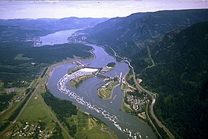
The river is 1,243 miles (2,000 km) long, and its largest tributary is the Snake River. Its drainage basin is roughly the size of France and extends into seven U.S. states and a Canadian province.
This month's event will fly us over the upper reaches of the river on its southern journey, with a good number of touch and gos to try.
The Columbia has 40 dams along its length and this flight will take you over some of them - watch out for them as you fly the route, which is easy to follow and will present some interesting touch and gos.
The Columbia River is the largest river in the Pacific Northwest region of North America.
The river rises in the Rocky Mountains of British Columbia, Canada. It flows northwest and then south into the US state of Washington, then turns west to form most of the border between Washington and the state of Oregon before emptying into the Pacific Ocean.
The river is 1,243 miles (2,000 km) long, and its largest tributary is the Snake River. Its drainage basin is roughly the size of France and extends into seven U.S. states and a Canadian province.
This month's event will fly us over the upper reaches of the river on its southern journey, with a good number of touch and gos to try.
The Columbia has 40 dams along its length and this flight will take you over some of them - watch out for them as you fly the route, which is easy to follow and will present some interesting touch and gos.
CBB9 Osoyoos 12/30
057 Scott 15/33
W01 Tonasket Mun 15/33
KOMK Omak 17/35 NDB OMK 219
S35 Okanegon Legion 04/22
S97 Anderson 07/25
S10 Chelan Mun 02/20 Full Stop Landing
5WA5 Ross Private Strip 09/27
KEAT Pangborn Meml 07/25, 12/30
WA68 Vantage 16/25 07/34
M94 Desert Aire 10/28
6WA3 Green Acres 16/34
KRLD Richland 07/25, 01/19 NDB RL
32WA Compressor Station No 8 06/24
There's a PlanG route available in the forums
Back
More News
Social Networks
Like our page, follows us and subscribe!